Subscriber Benefit
As a subscriber you can listen to articles at work, in the car, or while you work out. Subscribe Now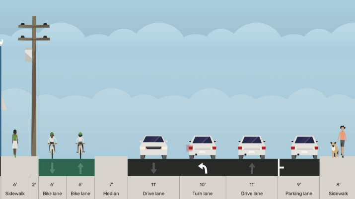
Construction began Monday on the so-called “road diet” project on West Michigan Street in Indianapolis, a $4.7 million “traffic-calming measure” that will reduce the number of lanes for motorized vehicles while adding bike lanes and on-street parking while improving pedestrian access.
Speaking at Christamore House on Monday, Indianapolis Mayor Joe Hogsett said discussions with Haughville residents about West Michigan Street in 2020 showed concern about the West Michigan corridor.
“The response was that six lanes of traffic on a road without a bike lanes and without other traffic-calming measures contributed to a sense of danger for pedestrians walking along Michigan Street,” Hogsett said.
The road will be reduced from six total lanes of car-focused traffic to one lane on each side, beginning at Holmes Avenue and ending at White River Parkway West Drive.
Construction crews will decrease the width of the street by adding a bike lane protected by a natural barrier, on-street parking and enhanced sidewalks with ADA-compliant ramps. The project is mostly being funded through a federal grant to the Indianapolis Metropolitan Planning Organization. The city will match 20% of the cost.
The nearly two-mile long bike path will connect to the B&O Trail, providing the first continuous connection from Indianapolis to Speedway for cyclists and pedestrians.
The project was initially slated to take two construction seasons, but will now be completed in one. There will be minimal interruptions to local traffic, according to Brandon Herget, director of the Department of Public Works, with at least one lane and one sidewalk remaining open throughout the roadwork.
City-County Council President Vop Osili said he spent many of his childhood years in Haughville. During that time, the White River felt more like a “moat” that cut off Haughville and near-west-side residents from the growth of downtown.
“The more we’ve learned over the past several years about the principles and practices upon which a safe, healthy and equitable city is built, the more we understand how central the ideas of physical and cultural connectivity are to achieving those goals,” Osili said. “The Michigan Street road diet project is a tremendous step forward in building that connectivity.”
The project is part of the city’s $1.1 billion, five-year infrastructure capital plan. The city expects to spend $443 million as part of that plan this year.
Also this year, the Department of Public Works will begin converting Michigan and New York streets from one-way streets to two-way. Michigan Street will become two-way between College Avenue and Ellenberger Parkway. New York Street will be converted between College Avenue and East Pleasant Run Parkway.
Those conversions are also considered traffic-calming and will cost an estimated $13 million. The completion date is set for summer 2024.
Nearly $42 million will go toward trails over the next five years. This year, the Cultural Trail will expand with two new segments: on South Street from Capitol Avenue to New Jersey Street, and on Indiana Avenue from St. Clair Street to 10th Street and west to Riley Drive. The projects will add about two miles to the trail.
College Avenue from Market Street to St. Clair Street will also become two-way street in a $2 million project.
The Nickel Plate Trail will run along the former rail line for just over 10 miles and connect to the south end of the Fishers portion, at 96th Street. The city will spend $12 million on the multiuse path.
Other pedestrian- and cyclist-safety focused investments in the plan include $5.6 million for remedying areas with high numbers of pedestrian crashes. Just more than $3 million will go toward rehabilitating or creating new sidewalks.
Please enable JavaScript to view this content.
Beautiful. Needed.
Are additional details available for the below mention in the article? Specifically, the trail will run from 96th street at North, down to where exactly?
“The Nickel Plate Trail will run along the former rail line for just over 10 miles and connect to the south end of the Fishers portion, at 96th Street.”
The Nickel Plate Trail is planned to be routed southwest generally on the former railroad bed from 96th St to 42nd St at the north side of the State Fairground property.
The Trail will continue west along 42nd St to connect to the Monon Trail near the State Fairgrounds.
Thank you Jerry!
Are there plans for an overpass or underpass at 96th street? You’d have better luck crossing I-69 on foot.
How about finishing one project first. The three block stretch of Meridian just south of Morris hasn’t been touched all winter.
Infrastructure projects are planned years in advance. It’s a complex web of research, permitting, and funding. The block stretch you’re referring too is probably on a list somewhere or already getting planned out.
Amazing all around.
More decorating in the streets. Quick question: When in recorded history was traffic ever calmed by being snarled and stopped? Throttling vehicular traffic, forcing 6 lanes of flow into two – what could go wrong? You’re about to find out. I’ll give you a preview: Pedestrians will actually find it *more* difficult to cross in many instances because forcing that much traffic into two lanes causes the train of cars never to have a gap.
This city has a syndrome, a sickness, of decorating in the streets: removing traffic lanes, inserting bumpouts and islands and feel-good-about-being-green drainage swales. Not to mention the new-style crosswalks, branded with the names of rich people and looking like something from a high-school homecoming committee. All with the goal of making vehicular traffic “calm” – by which they mean in a decorator-caused traffic jam.
Other cities that have tried this before and seen the results you belittle. You should see the economic development effects of tearing out downtown interstates, it’s amazing.
You’re asking local residents to sit down and shut up to accommodate the desires of people who live far away to get somewhere a couple minutes faster. It’s about time local residents have a say … and if you want to have a shorter commute, maybe move closer.
When College Avenue between Broad Ripple and 38th Street was changed from 3 traffic lanes to 2 to accommodate the Red Line (which also limited left turns to intersections with traffic signals), the result was a very real calming effect. Not only did the transformation increase property values along College Avenue, it made for safer vehicular traffic as well as an upgraded mass transit option for those who eschew cars.
And here we see the agenda: “those who eschew cars” are the allegedly served demographic. These all-knowledgeable Portland-style planners seek to destroy Indy’s vehicular traffic grid to create demand for light rail, the holy grail. [See “People Mover”, downtown Indianapolis, 2003-19.]
The agenda was right in the article:
“discussions with Haughville residents about West Michigan Street in 2020 showed concern about the West Michigan corridor.
“The response was that six lanes of traffic on a road without a bike lanes and without other traffic-calming measures contributed to a sense of danger for pedestrians walking along Michigan Street”
The agenda was to serve residents who’d rather not play human Frogger against random suburbanites who don’t live in the area and like to blow through at 50mph.
Can either the City or State update Keystone and 86th St. interchange. What a disgrace. The ramp on to 86th St. needs widened. Weeds, trash, overgrown trees, no lighting, poor pedestrian sidewalks/crosswalks, etc. To be one of nicest part of Indy the entrance and interchange to the Fashion Mall needs some major improvement. Again Indy look at Carmel up the street.
Robert, you get what you pay for (and you don’t get what you don’t pay for).
Carmel, with property tax valuations that are much larger on average than Indianapolis, can afford to spend more on streetscapes. Having move here from the east coast more than a decade ago, it didn’t take long for me to realize how undertaxed Hoosiers actually are.
Just imagine if the 377,000 households in Marion County paid on average an extra $100 a year in property taxes. That would give us nearly $38 million more dollars to spend making our city a nicer, more appealing place to live (and which would, in turn, increase property values).
The mayor came to my neighborhood to take pictures last week. The redid one small portion of a road and he left. I’ll believe this when I see it.
Making Indianapolis less driver friendly, one bad project at a time. Should make the existing streets reasonable to drive on before spending billions on “traffic calming measure(s)”
Steve, direct your complaint to the Republican state legislators who screw Indianapolis with an unfair road funding scheme that gives rural (i.e., empty) counties more money per mile for road maintenance than the state capital gets.
https://fox59.com/indiana-news/indianapolis-mayor-wants-more-equity-in-road-funding-from-state/
The streets are driver friendly. Speed limits will be followed, accidents will decrease, and driver will reach their destinations within 2 minutes of current travel time. One should note the short distance of this roadway improvement that will benefit pedestrians, bicyclist and drivers. Streets are multi-modal.
Should Michigan Street be deem non-friendly, then the affected vehicle can be directed by its drive to another parallel, wider, and perceptually friendly street.
Note that a portion of Michigan from the Kroger a block or two east already has only one through traffic lane EB and two WB. This probably won’t slow things down much more than the existing bottleneck.
It’s truly amazing how car focused we are in Indiana. I’m one of them myself but I’m ride my bike to work on nice days. It’s like some of the above commenters haven’t learned to ride a bike, experienced OTHER CITIES, or realized better modes of transportation exist.
The Mars Hill area in Decatur township has no sidewalks requiring people to walk on the highway or streets. I have seen mothers pushing their children in strollers on the should, in weeds, and even seen electric wheel chairs down the road. The bus stop at Kentucky and Lynhurst requires people to stand in the ditch to wait for a bus. Along Kentucky Avenue people walk down the railroad tracks.