Subscriber Benefit
As a subscriber you can listen to articles at work, in the car, or while you work out. Subscribe Now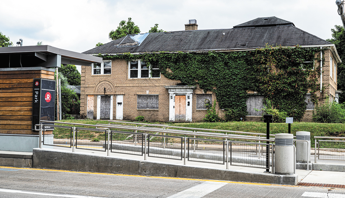
Indianapolis leaders want to encourage denser development near the city’s bus rapid transit lines and deprioritize cars, so they’ve changed zoning laws to help make it happen.
Earlier this month, the Democrat-controlled City-County Council voted 20-5 for new development standards that add residential and mixed-use districts to push bus usage, walkability and density county-wide.
The ordinance will go into effect Nov. 1, nearly 99 years to the day since Indianapolis started regulating development, according to a city timeline. But its provisions tackle standards introduced more than half a century ago, when Indianapolis and Marion County united as a consolidated government.
Before Unigov, Indianapolis developers focused on maximizing leasable space, with parking behind buildings or to the side, said Sean Northup, deputy director of Indianapolis’ federally designated Metropolitan Planning Organization. But a series of changes in the 1960s switched the emphasis toward car-oriented development, with more parking and buildings that were shorter and farther apart.
“What they did was make it really hard to construct the city that was already in place,” Northup said.
“I live in Broad Ripple, and if my house were to burn down, I would need a variance to rebuild it, because it goes too close to the lot lines,” Northup said of his 1910s-era home.
Today, Indianapolis planners are flipping the script on 1960s-era development, with a stronger emphasis on public transit and pedestrian-friendly walkways.

“It’s ironic that we have to do this,” said Brooke Thomas, who directs strategic planning at IndyGo and previously worked as a senior planner for Indy’s Department of Metropolitan Devel-opment. “We’re just having to undo what zoning did,” she added.
Red Line and beyond
IndyGo, Indianapolis’ public transit authority, hasn’t had the easiest go in its efforts to bulk up transportation options for what’s now a car-oriented city.
The Red Line, the city’s first bus rapid transit line, encountered delays before it finally opened in September 2019, as well as major cold-weather range problems with its electric buses. Ridership dropped during the pandemic, though it is on its way back up. Two more lines are planned.
“I think the jury’s still out to some degree” on the rapid lines, said Jeremy Stephenson, managing partner at real estate company 1820 Ventures, which is developing a mixed-use apartment complex on the near-east-side Elevator Hill campus. “I mean, we introduced the Red Line, and then we had a pandemic. And so, it’s hard to know what effect transit is going to have upon development to the broader community.”

The obstacles are also written into Indiana code. The same law that led to new funding for IndyGo also saddles the agency with privately raising part of its operating costs and bars Marion County from spending public money on light rail.
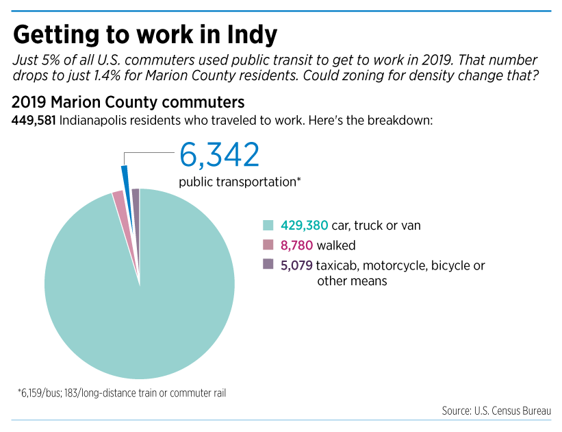
But thousands of people living in Marion County don’t have cars in a city built for personal vehicles. Nearly 70,000 residents carpooled, took the bus, rode a long-distance train, biked, walked, or taxied to work in 2019, according to U.S. Census Bureau estimates.

“Not everyone uses cars, is one thing, and … not everyone has a car,” said City-County Council President Vop Osili, who co-sponsored the ordinance and sees transit as strongly linked to housing.
“When you make housing decisions on issues like transportation and access to amenities, this provides a greater range of options for those households that don’t have access,” Osili added.
Rule changes could make it easier for city dwellers to get around on the Red Line, the first bus rapid transit leg, and on the Blue and Purple lines when they’re built. One set of zoning standards will cover plots of land that are even partially within 1,000 feet of the rapid lines.
The goal is to boost more developments that mix housing, business, recreation and transit in denser areas. The city hopes to build a “critical mass” for the rapid lines by creating the space for more people to live, work and play near the bus lines and other amenities.
“Park space, healthy food options, grocery stores, entertainment and retail—that’s not just reserved for a certain segment of our population,” Osili said. “It becomes attainable.”
The focus on transit comes with a push back on prioritizing cars in areas near the rapid lines. The new rules limit the square footage of certain projects and block or heavily restrict car-only developments like gas stations, car washes and drive thrus. New parking areas would be limited to garages.
The city, in the new ordinance, indicated that designing around car travel can “undermine public and private investments” in public amenities like buses, bike lanes and wider, pedestrian-friendly sidewalks.
“It’s important that land uses along those [lines] are maximized to support those public investments,” said Jennifer Milliken, senior director of the Urban Land Institute of Indiana, which was a consultant on the amendments. “Ideally, we would like to see that land-use patterns along the lines have both housing, so that people can easily use the lines to get to and from home, as well as businesses and destinations,” essentially setting the rapid lines up for success.
Although this type of development de-emphasizes vehicles, the Department of Metropolitan Development, which is behind the new rules, says it’s not trying to cut out your car.
Cash crunches
“Nothing we’re doing is trying to replace or get rid of cars,” said Shannon Norman, the department’s principal planner on the proposal. “Cars are a right. People can drive them. People can have them. But we do understand that, when you have an auto-focus, or auto-centric development, what you’re asking people to do is compete with those cars.”
That competition can endanger pedestrians, Norman said.
In 2019, 25 pedestrians were killed and 282 were injured in vehicle crashes in Marion County alone, according to Indiana’s annual County-Level Crash Data report. Out of 364 collisions with pedestrians, that’s a fatality rate of about 7%—several times higher than the 0.1% fatality rate for Marion County drivers that year, despite the nearly 64,000 crashes recorded.
The changes also might encourage developers who want to build densely but now often have to go through a lengthy, expensive process just to get permission. That can sometimes mean sitting on a property for a year while waiting for a variance, Northup said, draining a project’s financial feasibility.

“It’s a bit of chicken and the egg,” said 1820’s Stephenson, “in the fact that the development community needs to give options that are close to [transit], in order to boost ridership, and at the same time, we need to be able to see strength in the market, and use it so that we invest in projects near [transit].”
Those challenges apply off the bus rapid transit lines, too. Current zoning doesn’t allow for denser, leafier, courtyard-style housing, where multi-unit buildings are arranged around small pockets of open green space. The new ordinance will make that development style legal “by right” again across the county, with no special permission needed.
Other county-wide zoning rules include additional design standards for the handful of residential and mixed-use zoning districts it creates, covering common spaces like patios, plazas and rooftop decks, and requiring more pedestrian-oriented architectural details like windows and canopies. New sidewalks will also need to be wider.
Full circle
As foreign as designing around pedestrians might seem in Indianapolis, transit-oriented development advocates consider it a return to Indy’s past.
“The core of Indianapolis grew up around our streetcar network,” Thomas said. “That’s why we have these little commercial shopping and dining ‘stops’ all up College Avenue, for example.”
“Areas like Fountain Square and Broad Ripple, those areas historically have been shaped by transit—everything from buses to trolleys,” Norman said. “My grandmother came from Kokomo to Indianapolis every Monday morning and stayed until Friday to go to nursing school [65 years ago]. She came by bus, and used the bus the entire time she was here. And she was right on the edge of Fountain Square.”
In recent years, Norman said, Indy planners have been studying those long-ago “best practices,” like adding more benches, plants and trash cans, and having businesses that front sidewalks instead of sitting behind small seas of parking lots.
Planning around the bus rapid transit lines was in part funded by a grant from the U.S. Department of Transportation’s Federal Transit Administration, which announced a pilot grant program for transit-oriented development planning in 2018. IndyGo received $320,000 in federal money, and split an $80,000 match with the city’s Department of Metropolitan Development, according to IndyGo.
City meetings with a consultant in January 2020 led to talks with IndyGo and the Metropolitan Planning Organization, Norman said, followed by drafting through the spring and a virtual “talking tour” with a list of nearly 100 stakeholders in the fall.
The changes will go into effect in November. The regulations will apply only to new developments and significant redevelopments moving forward.
“We’re putting out a pretty good bet on the fact that transit is going to be good for our city, and so to be able to have transit-oriented development options and a toolbox to use it better suits those kinds of locations,” Stephenson said. “I think the market will respond to development if people respond first to transit as an option.”•
Please enable JavaScript to view this content.
I’m surprised this wasn’t done when the red line was approved. Glad it’s happening now.
I agree. Every direction for 100 yards from a BRT station should be zoned for high-density multi-story commercial, office, and multi-family residential.
Brent, did you read the part of the story that talks about the neighborhood scale nodes on College? That’s what is appropriate in many parts of the city. (2 or 3 story mixed use buildings with neighborhood retail/commercial and apartments). Downtown scale isn’t appropriate everywhere.
Interesting MDC hearing on August 18th. The developer’s over-reaching mixed-use project along transit routes at 22nd and College was unanimously voted down. Some reasons: too dense (units per acre) and too big (bldg mass) for the neighborhood. Neighbors presented a persuasive remonstrance case. The MDC was skeptical. City planners’ presentation contained uncertainties. Even their “transit-friendly” and “affordable housing” rationales could not persuade the MDC that the project was just too much for the site and would have negative impacts on the neighborhood.
http://indianapolis.granicus.com/player/clip/21315?view_id=3&redirect=true
(second petition heard)
Why the MDC was skeptical of Citizen Park Apartments when the City-County Councilors representing the area were in favor, the neighborhood association was in favor and there’s ample precedent for the height, density and massing in the immediate area is mystifying. The only significant issue where there was universal agreement was that the vehicular access point shouldn’t be from the alley. Hours and hours of negotiation between the developer, neighborhood and DPW to relocate that access to the College frontage was flushed down the drain in response to a remonstrance doesn’t represent the Fall Creek Place neighborhood at large or even the majority opinion of adjacent property owners. Unbelievable….
Oh, it’s believable. It appeared that there was a lot of confusion over what the MDC was voting on, since the planning staff was advocating for the vehicle access to be from the alley, but the letters from the two city-county councilors apparently conditioned their support on it being from College Avenue, which I believe would require another variance. If I heard correctly though, the planning administrator seemed to dismiss the need for an additional variance instead of explaining the rationale for the ordinance requiring vehicular access from the alley. Maybe the petitioner might’ve been better served by seeking a continuance to get the city-county councilors and planning staff on the same page and to formally amend their request to include a variance for the curb cut to be on College Avenue.
What kind of negative impacts to the neighborhood would there be?
It would be interesting to see red line ridership numbers, but those are always hidden to protect the Agenda and if forced, they can just scream “pandemic!!”
Ridership is reported monthly in the Board reports, in the same area, and in the same format each month. This is public information available with a few clicks to the Indygo website. Indianapolis as other cities noted significant ridership decreases due to the pandemic however the strongest routes today reflect the strongest routes in the 1940s, 1950s, 1960s, 1970s, 1980s and 1990s: Washington (proposed Blue Line and former streetcar key line), Meridian (now Red Line), College (now Red Line north of 38th and last streetcar line), 10th Street (former key streetcar line), East 38th Street (proposed Purple Line), Madison Avenue (former interurban corridor replaced by bus). But other corridors have performed better than expected: 86th Street, Keystone, and the Eastside Circulator (Post Rd/Mitthoeffer Rd) as the city has grown and transit needs expanded far beyond the pre-Unigov Indianapolis city limits.
The change with Uni-gov was unfortunate as it ignored physical aspects of development in the core city and the less densely developed surrounding townships. A better plan would have retained the planning guidelines for ‘old’ Indianapolis and also accommodate more auto-related development in the outer areas. However, the unappealing seas of parking in front of practically all development along many corridors — 86th Street, Madison Avenue, Washington Street, etc. — detracts from a sense organized and attractive development. A drive from the airport along West Washington Street is readily enough to make one run for the first return flight to anywhere. I digress.
Emphasizing development along major transit lines is not a novel or new idea but reflects and return to sound planning principles that have guided city growth for 100 years. This does not detract from single family houses nor auto use. The objective is the bolster development immediately adjacent to strong transit corridors — including but not only BRT lines — to provide walkable convenient access to transit and destinations throughout the network. Adjacent streets would remain predominantly single family and, ipso facto, more auto oriented.
A key point missing from this article is the share of transit to key destinations such as downtowns or other activity centers. While the overall share of transit to all job in a area may amount to a small share, the transit share of trips to downtown and some employment centers is much higher. The Indygo service improvement plans and route restructuring focused the majority of improvement on the route segments which generate the higher ridership. Indygo as other smaller systems can cite that more that 70 percent of ridership occurs on 10 percent or fewer of routes. However, lower ridership routes remain integral and necessary elements of the system as do low volume roadways remain elements of the roadway and street system. However, in areas and along corridors where riderships warrants only hourly service, alternative on-demand service via Uber or Lyft or taxi providers should be made available to nearby destinations or to a transit node with frequent service,
This was the plan by IndyGo and the City all along, not to provide transportation in areas that need it, but to move the population to transportation routes. They denied this in meeting after meeting for the Red, even though their graphics illustrated multi level construction all along the route. Does this mean that developers can now just buy homes along College Ave., tear them all down and construct apartments? What will building a development mean when you aren’t going to have available parking for tenants and have removed parking from the street to accommodate transit, as the Red did, by removing parking in front of the very businesses they purport to serve ?
Then it’s always brought up about the trollies in the old days. Well, those little business nodes on corners were walkable to the neighborhood. Why? We only had one car families back then, the city was much smaller and jobs were centralized.
If the plan for the Purple goes as planned, it will place the bus again in the middle of the street and reduce vehicular traffic to one lane in either direction on a large portion of East 38th, reduce or eliminate many left turns, shorten any left turn lanes as well as have poor timing on left turn lights.
The current Red on College brought more traffic on all side streets and requires residents to make u-turns, or travel blocks out of their way to get to their destinations.
If IndyGo wants to speed thing up, all they have to do is run more buses more often in areas where they are needed and not lock them into a specific locked route. It’s not rocket science.