Subscriber Benefit
As a subscriber you can listen to articles at work, in the car, or while you work out. Subscribe Now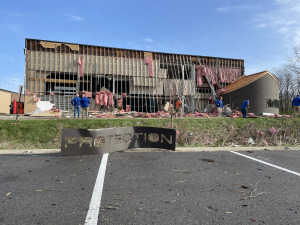
Violent storms and tornadoes tore through cities from Oklahoma to Indiana during what could be a record-setting period of deadly weather and flooding, destroying homes and sending debris nearly 5 miles into the air in one location.
Dozens of tornado and severe thunderstorm warnings were issued Wednesday and early Thursday from Texas to West Virginia as storms hit those and other states. Forecasters attributed the violent weather to daytime heating combining with an unstable atmosphere, strong wind shear and abundant moisture streaming into the nation’s midsection from the Gulf.
Indianapolis area
A line of strong storms producing several possible tornadoes passed through central Indiana on Wednesday night, causing widespread power outages and flooding, downing trees and damaging buildings. By Thursday morning, residents and first responders were sifting through damage across the Indianapolis metro area and at least one person had died.
According to WXIN-TV Channel 59, a 27-year-old Danville motorist was killed Wednesday evening after hitting downed power lines.
Power outages continued into the mid-morning Thursday. AES Indiana reported over 24,500 power outages as of 10 a.m., and about 3,000 Duke Energy customers around Indianapolis were still without power.
Indianapolis Public Schools announced that Thursday would be a remote learning day for students, as several buildings across the district were still affected by power outages. At least 10 districts in Indiana have canceled or delayed in-person classes Thursday.
National Weather Service crews will be canvassing areas across the state Thursday to determine the extent and severity of storm damage. Gov. Mike Braun said in a written statement Thursday that his office was coordinating with agencies across the state.
“During times like these, the best of our Hoosier hospitality shows in how we care for our neighbors and communities,” Braun said.
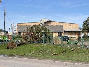
A tornado reported near Midtown Carmel shortly after 9:30 p.m. uprooted trees, knocked down a signal tower, overturned signs and damaged buildings near Third Avenue and Gradle Drive. Among the damaged buildings was the Carmel Ice Skadium.
Hendricks County remained under a travel watch Thursday morning, recommending only essential travel, such as to or from work or for emergencies.
In Brownsburg, Sur La Table’s main distribution center at 901 E. Northfield Drive partially collapsed, trapping a woman in the wreckage for more than 40 minutes. Two other people were helped from the site by coworkers.
Overnight interstate closures due to hazardous travel conditions were mostly resolved Thursday morning, although standing water remained on some surface roads. At one point during Wednesday’s storm, all lanes of Interstate 65 southbound were temporarily closed, and a stretch of the interstate in Delaware County was partially closed due to an overturned semi.
Five semitrucks were blown over on I-65 near Lowell, Indiana, state police reported.
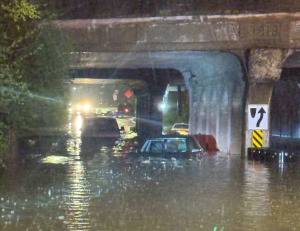
Indianapolis police released photos of high water at Southeastern and South Sherman avenues at about 10:50 p.m. Wednesday. There were no people in the vehicles, officials said.
Nearly 40 Indiana counties were under a flood watch as of 9 a.m. Thursday.
And there’s more to come: Severe storms could return to the area as soon as Friday evening. An excessive rainfall outlook issued early Thursday by the National Weather Service in Indianapolis warned of additional periods of heavy rain through at least Saturday, with another 3-4 inches of rainfall near the Interstate 70 corridor.
Nationwide
Sgt. Clark Parrott of the Missouri Highway Patrol said at least one person was killed in southeast Missouri, KFVS-TV reported. In northeast Arkansas a rare tornado emergency was issued as debris flew thousands of feet in the air.
The Tennessee Department of Health confirmed two weather-related fatalities, one in McNairy County and the other in Obion County, the Tennessee Emergency Management Agency announced early Thursday.
The coming days were also forecast to bring the risk of potentially deadly flash flooding to the South and Midwest as severe thunderstorms blowing eastward become supercharged. The potent storm system will bring “significant, life-threatening flash flooding” each day through Saturday, the National Weather Service said.
With more than a foot of rain possible over the next four days, the prolonged deluge “is an event that happens once in a generation to once in a lifetime,” the weather service said. “Historic rainfall totals and impacts are possible.”
More than 90 million people were at some risk of severe weather in a huge part of the nation stretching from Texas to Minnesota and Maine, according to the Oklahoma-based Storm Prediction Center.
A tornado emergency—the weather service’s highest alert—was briefly declared around Blytheville, Arkansas, on Wednesday evening, with debris lofted at least 25,000 feet, according to Chelly Amin, a meteorologist with the service.
“It’s definitely going to be a really horrible situation here come sunrise in the morning in those areas,” Amin said.
A tornado was also reported on the ground near Harrisburg, Arkansas, in the evening.
The Arkansas Division of Emergency Management reported that there was damage in 22 counties due to tornadoes, wind gusts, hail and flash flooding. At least four people were injured, but there were no reports of fatalities as of Wednesday evening.
In Kentucky, a tornado touched down Wednesday night around Jeffersontown, a suburb of Louisville, passing the Interstate 64 and Interstate 265 interchange, according to the weather service.
Four people were injured in Kentucky when a church was hit by debris from a suspected tornado, according to Ballard County Emergency Management. One person was in critical condition, while the others have non-life-threatening injuries.
Floods could inundate towns, sweep cars away
A line of thunderstorms dropped heavy rain through parts of Indiana on Wednesday night. At least one street was flooded in Indianapolis, with water nearly reaching the windows of several cars, according to the city’s metropolitan police department. No one was in the vehicles.
Additional rounds of heavy rain were expected in parts of Texas, the lower Mississippi Valley and the Ohio Valley from midweek through Saturday. Forecasters warned that they could track over the same areas repeatedly, producing dangerous flash floods capable of sweeping cars away.
Middle Tennessee was looking at severe storms followed by four days of heavy rains as the front stalls out and sticks around through the weekend, according to NWS meteorologist Mark Rose.
“I don’t recall ever seeing one like this, and I’ve been here 30 years,” Rose said. “It’s not moving.”
Rain totaling up to 15 inches was forecast over the next seven days in northeastern Arkansas, the southeast corner of Missouri, western Kentucky and southern parts of Illinois and Indiana, the weather service warned, with some areas in Kentucky and Indiana at an especially high risk for flooding.
Please enable JavaScript to view this content.
The Brownsburg & Carmel tornadoes were caused by the same part of the same storm. There is a chance that there was a single tornado that went through Maron County. This would be consistent with the traffic light that was knowned down at Harcourt/86th & other storm damage in northern & northwestern Marion County.
We’ll have to wait for NWS to assess what happened.
I thought Mayor Brainerd outlawed tornadoes in Carmel? This must have not been a tornado, but the after-effects of the liberal commie paid protestors who attended Rep. Spartz’s meetings last weekend. Or perhaps some sort of natural reaction to her hot air…either way, it must have created a derecho-like effect that swept through Carmel and then out over Noblesville, and off to the north east…
The city should be ashamed of the state of the infrastructure immediately surrounding the train bridges along Sherman
Guess it’s had drainage issues for like 40 years. Definitely a shame.
The bridges are owned and built by the railroad more than 100 years ago, but they allow traffic to pass under the rail yard located there. The city HAS upgraded the infrastructure around these street so now they only flood in EXTREME events.
What really needs an upgrade are the idiots that see a flooded intersection and still drive through. If your take away from that picture was the stalled vehicles was the city’s fault then you might have missed the point of that picture.
That intersection has flooded since the day it was built, no new news there. Don’t go blaming the city now.