Subscriber Benefit
As a subscriber you can listen to articles at work, in the car, or while you work out. Subscribe Now
Have you ever wondered where Ralston’s Draft House on Massachusetts Avenue or the Alexander Hotel on Delaware Street got their names? Or, for that matter, where their streets’ names came from? The answer in each case is the same: Alexander Ralston, architect of Indianapolis.
![]() Ralston, who was born in Scotland in 1771, came to the U.S. after the American Revolution. An engineer, in 1791 he helped Pierre L’Enfant lay out the geometrical city plan of Washington, D.C., which became a strong influence for Ralston’s Indianapolis design.
Ralston, who was born in Scotland in 1771, came to the U.S. after the American Revolution. An engineer, in 1791 he helped Pierre L’Enfant lay out the geometrical city plan of Washington, D.C., which became a strong influence for Ralston’s Indianapolis design.
Ralston moved here in part because of his association with Aaron Burr. Ralston wanted to distance himself from Burr, vice president under Thomas Jefferson and the man who killed the first secretary of the treasury, Alexander Hamilton, in an 1804 duel.
In 1820, the General Assembly moved the state capital from Corydon on the Ohio River to what became Indianapolis. This reflected two priorities: Situate the capital centrally and take advantage of the White River, then thought to be navigable.
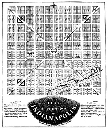
That same year, Ralston and Elias Fordham were commissioned to survey the new city, and the following year Ralston set about creating a city plan. Originally, he envisioned a city of one square mile, with the governor’s mansion in the center.
Ralston’s 10-block-by-10-block plan was aligned with the cardinal directions, with Meridian Street (Latin for midday) dividing the city into east and west halves. Washington Street, named for the nation’s most prominent founder and his eponymous city, separated north and south.
As Indianapolis architect William Browne Jr. has pointed out, Ralston appears to have named the east-west streets to the south after slave-holding states and those to the north after free states. He followed the same convention with the diagonal avenues, such as Massachusetts and Virginia.
Ralston adopted a similarly systematic approach to the north-south streets, choosing to name the eastern-most street after the eastern state of New Jersey and the western-most street after Missouri.
Ralston’s plan did not always win the day. For example, he had planned a Maine Street, but city officials thought that would lead to confusion with the main streets of other cities. Years later, Ralston’s Tennessee and Mississippi streets were renamed Senate and Capitol avenues.
Indianapolis (the “city of Indians”) officially became the capital of Indiana (the “land of Indians”) on Jan. 1, 1825. Its location near the White River and Fall Creek subjected it to frequent flooding, and early inhabitants battled malaria and cholera.
When the White River ultimately turned out not to be navigable and a Central Canal was abandoned, the city’s prospects appeared dimmed, but the rise of the railroads soon offered rescue, and the nation’s first Union Station was built in Indianapolis in 1853.
In 1827, the governor’s mansion was built in the center of what’s now known as Monument Circle. However, governors complained about the complete lack of privacy, and no officeholder ever lived there. Demolished in 1857, it was replaced by the Soldiers and Sailors Monument in 1901.
Not everything in Indianapolis bearing the Ralston name is named after the city’s architect. Ralston Avenue is named after Samuel Ralston, who rose from poverty to become Indiana’s centennial governor (1913-1917) and a U.S. senator.
Today, Indianapolis has grown far beyond Ralston’s original “mile square” to encompass an area of 361 square miles, ranking it the country’s 16th-largest city by land area. Unbeknownst to most, its inhabitants are officially known as Indianapolitans, who number nearly 900,000.
Alexander Ralston died in relative obscurity in his Indianapolis home in January 1827. The city he designed had served as the state’s capital for barely two years. His remains were later removed to Crown Hill Cemetery, where his gravestone bears an image of the city’s original design.•
__________
Indy Beacons celebrates Indianapolis in the year leading up to its 2021 bicentennial. Gunderman is chancellor’s professor at Indiana University.
Please enable JavaScript to view this content.

Very interesting article. Thank you for publishing it.