Subscriber Benefit
As a subscriber you can listen to articles at work, in the car, or while you work out. Subscribe Now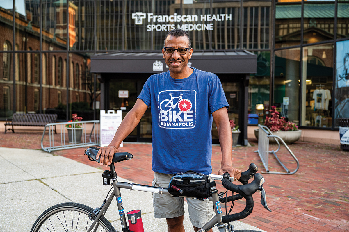
Damon Richards sold his car three years ago.
He bikes to the grocery store, his doctor’s office and to work (when he has to go to the office). On rainy days, Richards might take the bus. He uses his wife’s car sparingly, mostly to transport his 96-year-old mother or 90-pound dog.
But that’s possible because Richards lives downtown. Indianapolis’ core hosts most of his routine destinations and some of the city’s safest, most interconnected bike infrastructure.
“I’m able to [bike most places], because I, by choice, selected to live in a place where it’s possible,” said Richards, who also leads not-for-profit Bike Indianapolis.
That’s not an option for many area residents, but more choices are coming.

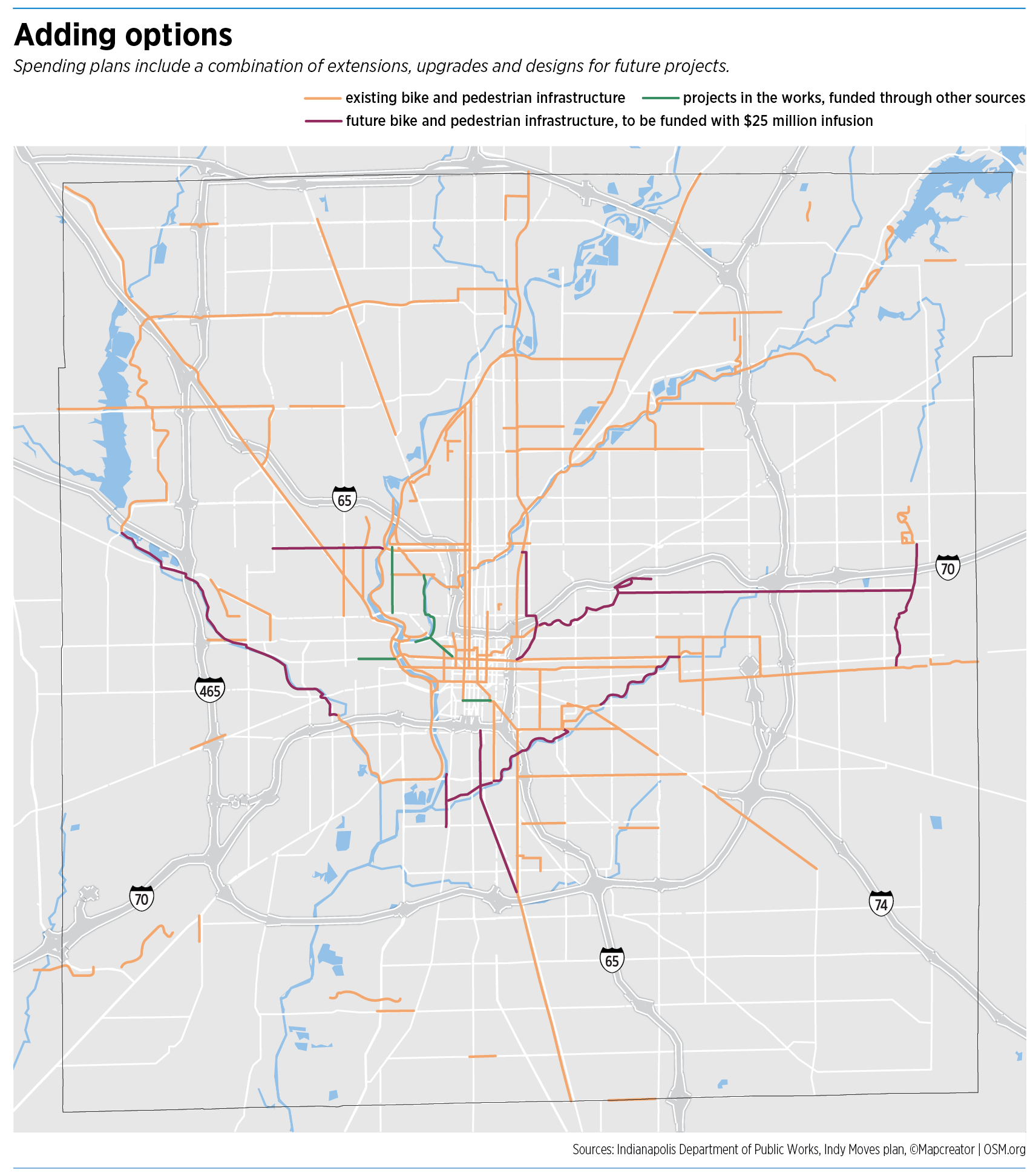
Indianapolis is putting $25 million toward a list of nine trail, greenway and road projects that could make it easier for bikers and pedestrians alike to get where they need to go—to work, play and run the mundane errands in between.
“As much as our trails and greenways are outdoor space, they’re also connectivity and part of the transportation network,” said Dan Parker, who leads the Department of Public Works.
Together, the projects would stretch from Indy’s west side, near Eagle Creek Reservoir, to the east side, along Grassy Creek. One leg would stretch north to Hamilton County, and another, south to Johnson County. Each connects to existing and planned trails, bike-friendly streets, bus rapid transit lines and city landmarks.
Two could be done as soon as 2023, with several more complete or underway by 2025.
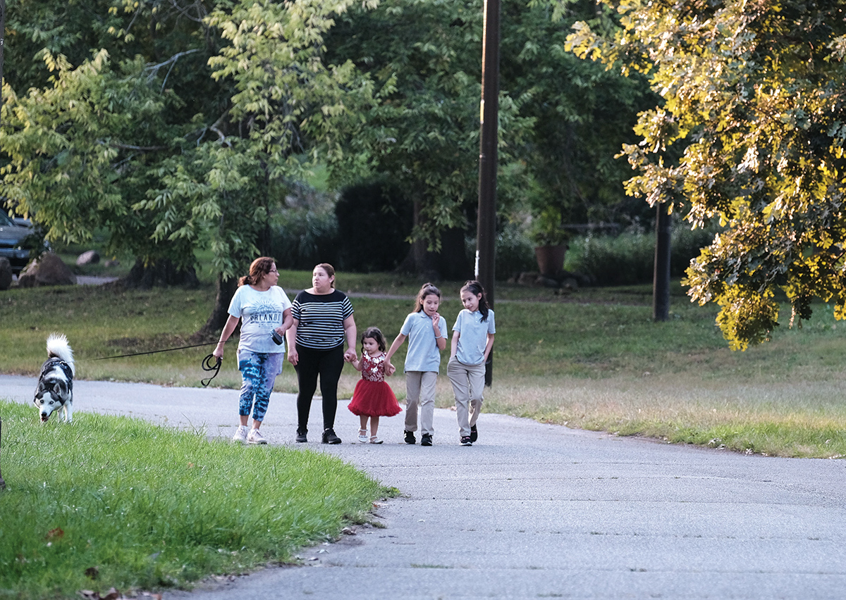
Trails and greenways, like the Monon Trail, are favorites for residents who want to get some fresh air. But bike- and pedestrian-friendly routes also help those who can’t get around by other means.
![]()
“I think people take for granted that these are recreational amenities,” said John Seber, executive director of the Central Indiana Regional Transportation Authority. This quasi-governmental organization obtains and helps allocate federal transportation funding and aims to advance options for suburban and rural residents.
“People need to understand that these [city] funds will also increase the opportunities for these people to use these trails for daily needs, like commuting to work, to school, traveling to the grocery store, doctor’s appointments, or simply getting to the nearest transit stop,” Seber said.
“There are a lot of people who use their bicycles not just for recreation, but for transportation,” Richards said. “Some of them by choice, like myself, and many others, out of necessity, because they don’t have a car.”
An estimated 38,000 Marion County households, or about 8%, didn’t have a car in 2019, according to the U.S. Census Bureau. That means finding other ways to get around, like carpooling, walking, biking or the bus.
About 86% of IndyGo riders reported having no access to a vehicle in a 2016 on-board survey of 4,000 people, the most recent available. But there’s not that much room for error.
“Our bus system is difficult to use,” Richards said. “If you’re trying to use it for your primary transportation, particularly if you’re in a job where being 15 minutes late could cost you your job, the buses run every 30 minutes. Miss one, and you’ve lost your job.”
The wait could be even longer beginning Oct. 10, when IndyGo will begin temporary schedule changes to make up for a driver shortage. Buses on two routes will come every two hours instead of one, and will run every hour instead of every 30 minutes on two other routes. IndyGo also plans to pause high-frequency service during rush hours on 11 routes.
Trails to 2025
Right now, options are limited for those who don’t want to be car-dependent or are car-less. Seattle-based Walk Score, which runs a public access walkability index for the United States, Canada and Australia, gives “car-dependent” Indianapolis a 31 for walkability, a 45 for bikeability and a 23 for public transit, all out of 100.

Chyri McLain-Jackson now works from home, but for her old commute, biking was a no-go. She lives in Brownsburg, and leads Indianapolis’ chapter of Black Girls Do Bike.
“I lived away from my job, so I drove,” McLain-Jackson said. “I looked at routes to get there, but was like, ‘Oh, no; it’s just too dangerous.’”
But longer-term plans for Indianapolis and central Indiana envision a transit network with more comprehensive alternatives to driving. Those efforts are getting a $25 million boost.
The City-County Council unanimously approved funding for the nine trail, greenway and road projects in September. Federal pandemic relief—like the American Rescue Plan Act, which allocated $420 million to Indianapolis—freed up money for initiatives like trails, according to city officials.
The Department of Public Works will lead work on the trail projects. So what’s at the top of the list?
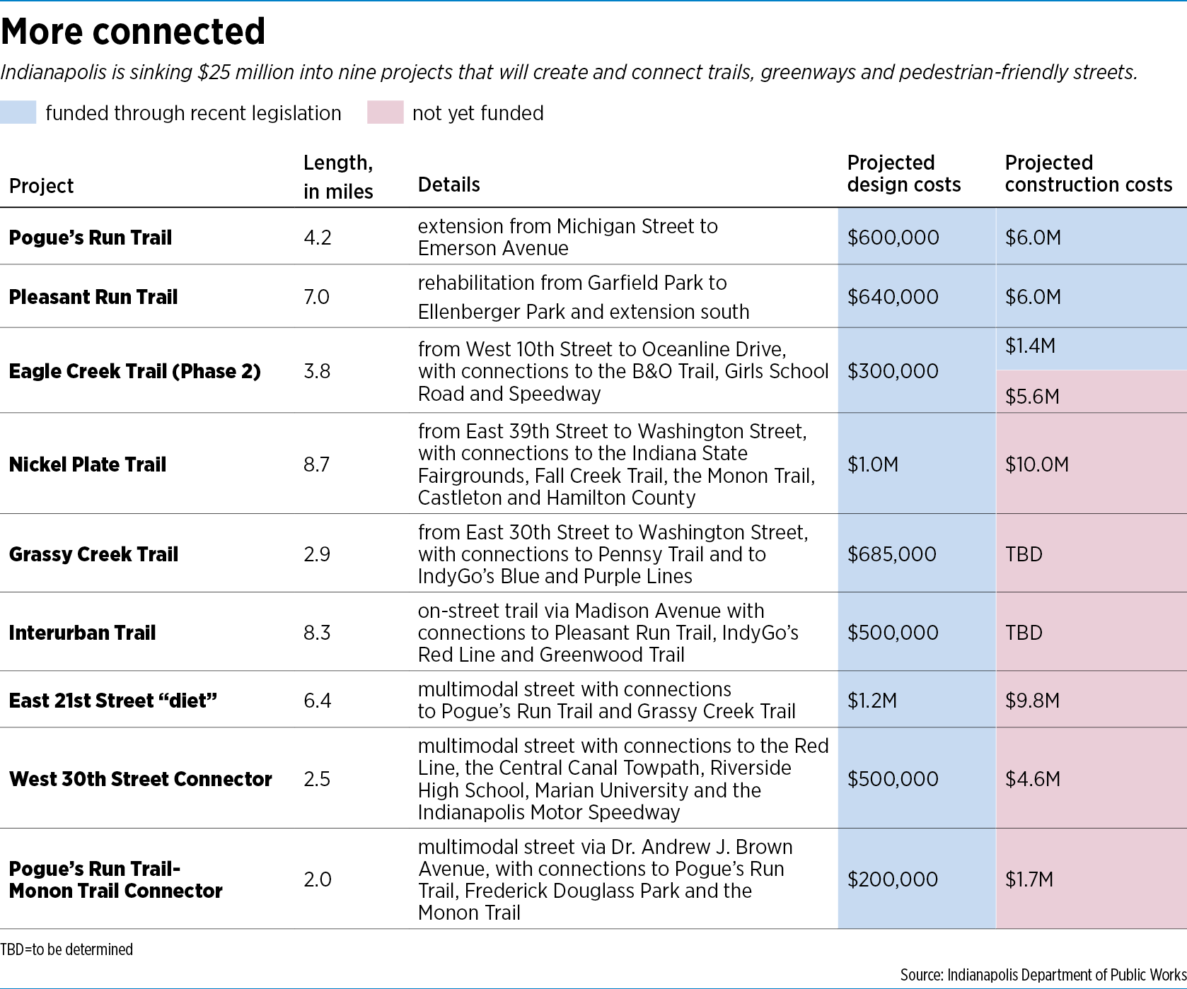
First, completion of Pogue’s Run Trail, at a cost of $6.6 million, and the rehabilitation of Pleasant Run Trail, plus an extension south, for $6.6 million. Design and construction for both projects are fully funded. Design is scheduled to take 12 months, with the projects bid out late next year and completed by late 2023, according to DPW’s Parker.
Next up is phase 2 of Eagle Creek Trail, which will eventually connect to the B&O Trail, Girls School Road and Speedway. DPW has $300,000 ready for design costs and $1.4 million set aside for a match required by the federally designated Indianapolis Metropolitan Planning Organization. The project’s $7 million price tag is pushed up by its flood-control function, which involves the Eagle Creek Levee and the U.S. Army Corps of Engineers. DPW employees are working on an application now, and if accepted, construction would start in 2025, according to Parker.
The $25 million will cover only design costs for the other six projects, which include the Nickel Plate Trail to Hamilton County; Grassy Creek Trail, which would have connections to two bus rapid transit lines; and the on-street Interurban Trail, which would extend from the Old Southside to Greenwood along Madison Avenue, hitting the Red Line and other trails on the way.
Three stretches of road—Dr. Andrew J. Brown Avenue, East 21st Street and West 30th Street—would get designs for multimodal makeovers, which, when built, would enable them to safely move cars, buses, bikes and pedestrians.
Making numbers work
DPW officials say the goal for the detailed designs is to further Indianapolis’ chances of landing state and federal funding. DPW plans to apply to Indiana’s Next Level Trails grant to help fund the Nickel Plate Trail, for example.
“The proposal is that much more competitive if we’ve already got a lot of it under design,” said DPW spokesman Ben Easley. “We’ve applied for it a couple times in the past and we keep hearing, like, ‘Let’s ramp it up. Let’s make it more competitive.’”
A “yes” from the Department of Natural Resources would give DPW three years to make Indy’s share of the Nickel Plate Trail a reality. It would be done by 2025.
Comprehensive designs could help DPW leverage characteristics of certain projects—like location in a flood zone—to get funds earmarked for those specific purposes. “With several of the other projects, getting them under design, it would be just, ‘Where do we go to find the dollars to do those projects?’” Parker said. “For example, Grassy Creek—is it a greenway-slash-flood-control project?”
DPW has also set aside $2 million for engineering costs and $4 million for a construction and land-acquisition cushion. Some could also go toward required local matches.
In total, the initial $25 million would complete or kick-start work on more than 45 miles of trails, greenways and multimodal streets. Finishing all the projects would take at least $50 million, excluding the two projects for which DPW hasn’t completed construction cost estimates.
DPW is also planning additional, smaller-scale projects with regular departmental funds as part of its 2021-2025 capital plan.
Going south
Bike and pedestrian access has already improved in Indianapolis—though it has a long way to go.
“If you live in the north half of the city, yes, projects that DPW’s done over the last couple of years have created connectivity between existing pieces of infrastructure,” Richards said. “Prior to that, we had a lot of short stretches you could use, but then you’d have to bounce back and forth on the street.”
But, he said, “The entire south side’s a problem” when it comes to bike-friendly infrastructure. “It’s hard to go east-west or north-south once you get below Washington Street.”
That problem has decades-deep roots. Creeks and other waterways are typically easy places to put new greenways, but when urban Indianapolis and suburban-rural Marion County unified in 1970 under Unigov, south-side creeks stayed privately owned.
“The master plan calls for a trail that comes out of Beech Grove … and there’s the Lick Creek, across the center of the south side. We own none of that land,” Parker said. “And there’s a trail called for starting in Franklin Township and running through the heart of Perry Township, [along] Buck Creek. But all of the property is private.”
“It’s very expensive to buy land,” he added. “And you’ve also got to convince people that it’s a good idea to have a trail going through their backyard.”
Inactive railroads are also prime land for new trails (e.g., the Monon Trail, the Nickel Plate Trail), but trains still lug dozens of freight-filled cars across all of the south side’s railroad tracks every day. And trail conversion involves land acquisition, anyway—in a 2012 decision, the Indiana Supreme Court ruled that the land underneath old rails is private property when it comes to new trails.
That ruling has delayed plans to widen the Monon Trail.
Big plans
Indianapolis’ vision would take millions of dollars, political will and years to carry out, but officials say whatever does get built could catalyze growth.
“The investments that the city has made in the Cultural Trail and the Monon and several other trails that are already done, there’s [been] tremendous economic development opportunities around trails because folks want to locate near the movement of people,” Parker said.
From 2008 to 2015, parcels within 500 feet of the Cultural Trail added more than $1 billion in property value, according to an assessment by Indiana University’s Public Policy Institute. In a 2014 survey, which was part of the same study, about 50% of businesses near the trail reported revenue increases, and more noted increases in customers. Some business owners said they’d chosen their location because of the trail.
The area around the Monon Trail has experienced similar effects.
“I like that, sometimes, on the trail, you can stop and there may be little restaurants or stores, because not all my biking is endurance biking,” said McLain-Jackson. “I like to get on the trail and say, ‘Hey, let’s go grab lunch and come back.’”
Other Monon users spend big bucks on trail-related expenses, including “transportation to and from the trail, as well as on bikes, shoes, maps and parking, than any other trail in the study, and second-most on clothing,” the 2017 edition of the Indiana Trails Study concludes.
But not everyone is out and enjoying the Monon. Just 5% of trail users had a household income of less than $38,000, according to the study, while fully 53% topped $90,000. Marion County’s median income that year, 2017, was about $48,000, according to the U.S. Census Bureau.
Could Indy’s cross-town trail plans also cross socioeconomic gaps?
At the Central Indiana Regional Transportation Authority, Seber is thinking of ways to expand commuting options via the new trails and connections they create. His organization offers workforce connectors from two IndyGo routes to Plainfield and Whitestown, plus carpools and vanpools throughout central Indiana.
“With the trails … it’s something we’re going to look at, and we may even—once we get a final map and some other things—because we’re developing some park-and-rides, too,” Seber said.
“Once people understand how these maps are going to interact—you know, there’s a system map—I think we’ll see that really open up the potential for some of these other commuter-type options.”•
Please enable JavaScript to view this content.
They need to start with maintaining the Monon and widening it as promised three years ago.
Did you not read the part about the Indiana State Supreme Court ruling in 2012 that determined land beneath the rail trails are private, and that is what has stalled the widening of the Monon Trail?
Yes, of course I read it.
How about someone comments on some details of what that means? and why it’s caused such a LONG delay? and why it’s impossible to get an update from Indy Parks on the status of their promised widening? and why no maintenance is being done on the current trail?
Another thought on the Monon — I don’t know the full chronology of the Monon construction, but why is it that the Monon Trail is so much wider to the north of Nora? I know, I know — Carmel, Carmel, Carmel. Still, seems since the portion north is also on the Monon railway it would be under the same rules.
Plus, the lack of maintenance on the portion of the Monon Trail south of 96th street is dangerous. The trail sides are breaking off and someone is going to get injured by hitting the broken edges, or the many potholes and big bumps made by the tree roots breaking up through the trail asphalt.
Do we have to wait until someone is seriously injured to get something done on that portion of the Monon? And Yes, they did promise this 3 years ago. This is especially frustrating when you see some of the construction across town on curbs and such that don’t seem to be in dire need of complete replacement.
I’ll inject some positivity here. All of this sounds great. I’m grateful for the trails we do have (not wide enough or too wide) and happy to hear a car dependent city like Indianapolis is further investing this alternative means of transportation. I haven’t had a car for 8 years, live in Fountain Square & use a cargo bike for my downtown businesses.
I notice Decatur township is not included in this. They would like things such as sidewalks. We have many elderly and poor who have to walk on busy roads such as Kentucky Avenue, Mann Road, Mooresville Road just to get to the drug store and grocery store. I have seen mothers pushing their children in strollers through the snow where there is no sidewalk or even a decent shoulder on the road. I have seen people in wheel chairs on Kentucky Ave, and Mann Road because no sidewalks. People walk on the railroad tracks because it safer than walking along Kentucky Ave which is a highway. I see people standing in a ditch with water to their ankles because the bus stop at Kentucky Ave and Lynhurst has no other place for them to stand and no enclosure. I contacted the city years ago to see about contributing to fix the bus stop and no response. Republican and Democrats administrations alike have ignored this area of town. I guess I should complain our sidewalks are not wide enough but of course we do not have many and if we do they are only a few hundred feet installed by one of our warehouses the city has given us. I was told years ago the city was going to install an all purpose path from Mooresville Road to Rockville Road on Lynhurst which has not happened. Almost all residential property has been converted to warehouse. The real attitude was revealed years ago when I was attending a local zoning organization when Hudnut’s driver said why don’t you guys get annexed by Morgan County where you belong?
The MONON Trail (phase 1) was built in the Goldsmith administration and has been barely maintained since. (20+ years).
The only bright spot has been the new bridge over 38th St. Maintenance of infrastructure and landscaping is the key the success of these venues… if Indy Parks can’t figure this out, it should be outsourced.
That’s your solution? Private indistry profiting off of taxpayer resources? That’s exactly what got us into this mess. If Indiana would quit giving gigantic tax breaks to every company who offers to bring a measley amount of low-paying jobs here, maybe we would have tax dollars to pay for things.
The Monon is great and literally nobody cares about widening it. That’s a waste of money. Since when was the Monon in bad condition? Twelve feet of busted as fault around 96th St, you’re joking right?… They just spend like $10M on the bridge at 38th St. Quit worrying so much about existing trails and focus on neighborhoods without bike lanes! Connect the rest of Indianapolis – an avid cyclist
Anything happening with the old northside Rail Road tracks that were torn out? The tracks that used to service the State Fair, running along Allisonville then between Allisonville and Binford, around the Kessler Blvd and 62nd street area? They removed the tracks, currently just gravel and overgrown weeds.
The Nickel Plate Trail will go through design as part of Circle City Forward Phase III. This makes it much more eligible for State and Federal grant dollars, since it would be ready for construction.
That’s called the Nickel Plate Trail. It’s mentioned in the story that they have funding allocated for design work, but not yet for construction.
Thank you AT. and Paul L. I appreciate it, I asked prior to fully reading and missed that. Thank you.
That’s going to be a game changer for those of us who want to bike-commute to downtown from Fishers as well as all the development sure to spawn along the Nickel Plate Trail. #PaveTheNickelPlate
Regarding the complaints about the maintenance of the Monon Trail. Has anybody walked the canal recently? Same thing there, the city builds something with never any plans or funding in place to maintain it.
The Monon Yard Neighborhood at 28th Street and the Monon Trail. I’ve been told today this is not an official entrance to the trail. Unbelievable 20 years and we can’t get DMD to remove the scrub trees, metal interstate barricade, or cover an open manhole so we can safely enter the trail. Just tired…
I’m all for more trails but I think we need to pay better attention to quality of the trails we’re building. For instance that map shows a trail along Allisonville Road. Anyone who’s travelled that road knows that “trail” is little more than a couple of stripes on the road and seems to end at several intersections only start again on the other side. There’s a world of difference between that and the Monon yet they are both called trails. I think we need to be more specific about what is a trail and what isn’t. It’s dangerous to ride a bike on Allisonville Road.
Quick story: a couple of years ago Noblesville was bragging about having completed 100 miles of trails. They even commemorated it with a monument on a trail. I live and ride here and could not find 100 miles of trails so I inquired where they were. The parks director sent me a map with lines denoting trails along many city streets that didn’t have trails or even sidewalks. When I asked how he justified calling those streets trails he replied that trail designation wasn’t an “exact science” and the city decided that streets that connect to trails can be considered trails. My objections went nowhere. The monument is still there.
Trails are popular and cities like to brag about having them but I think we need to hold our city officials accountable for creating trails that are more than roads with a bike lane or city streets that “double” as trails.